
A new entry for the new week :) We hired a driver, Meeky Yang, to bring us around Taiwan during our trip. He is highly recommended on the forums, extremely popular as well! I was lucky to be able to book him for a day. He arrived promptly at our hotel at 9am & we set off to our 1st destination - Yehliu Geo Park 野柳地质公园


野柳 is a cape on the north coast of Taiwan, in the town on Wanli b/w Taipei and Keelung.

Tickets to the park, priced at 50NT per pax.

The large crowd outside the ticket booth.


Let's venture in!

The map that shows you the layout of the place. A number of rock formations are given imaginative names, based on their shapes, with the most well-known "The Queen's Head".


The cape, known by geologists as the Yehliu Promontory, stretches approx 1,700 meters into the ocean and was formed as geological forces pushed Datun Mountain out of the sea.


We were told by Meeky that this place gained popularity over the years, as there was rumours that the famous Queen's head will "drop" off soon due to natural factors. So all the tourists/people flocked to the park to get a glimpse of the famous icon. Look at the huge number of tour groups who were in the park.


In the early days, local residents earned their living at sea and they relied on rice suppliers from inner land to offer rice to them. During transportation, some locals would use a sharp bamboo tube & pierce the rice sack, so that rice would flow out and the locals can collect it. As a result, rice traders often mentioned "the rice was stolen by the savages" where "steal" and "savage" are pronounced similar to Yeh (savage) and Liu (steal) in Taiwanese.


It was difficult to capture a (clean) shot with the hordes of people behind us. 

The statue of Mr Lin Tien-chen, which is a reminder of his brave actions in March 1964 when he tried to help a student who visited Yehliu and was swept to sea by the waves. Unfortunately, both Mr Lin & the student lost their lives. Upon hearing the news, President Chiang Kai-Shek gave orders to set up the statue in memory of the fisherman while his story was also included in textbooks for people to remember his brave acts.


Be careful not to venture beyond the red line for your own safety.


The place can get extremely windy and cold & you can hear sound of the waves sweeping against the rocks.


A long queue formed to take pictures with the famous symbol & we had to wait patiently for our turn :) It was assessed that the age of the rock is about 4,000 years old *WOW* and it gets the title because the shape appears like the side face of Queen Elizabeth.


Being in this park is like learning geography all over again, lol! I used to love both history and geography during lower secondary & was in a dilemma when we had to choose to study either one for upper sec. It was an internal struggle, but I choose history in the end.


The bridges are set up in the park to connect the lands where sea grooves are formed.


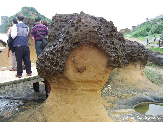
Owing to the differential erosion caused by weathering, the surface of the rock turns into the shape of the honeycomb. The flat, level rocks spreading across the land and are covered with holes of different sizes.


We stayed for almost 1 hour and by then, the crowd seemed to have disperse.


We didn't climb all the way to the top of the cape, which housed a light-house. When viewed from a distance, the Yehliu Cape looked like a turtle crouching down by the sea, henceforth, it was also nicknamed "Yehliu Turtle". 


The rocks have undergone weathering, which can be seen from all over the place. Yehliu is located in the subtropics zone with a temperature and humid climate. Each year, the place is under the influences of Northeast monsoon and wave erosion for over a 6-month period.


Randomly taking pictures with the various rock formations.

Sea creatures climbing onto the rocks, roaming around.


As you can see, we took lots of pictures for this place (I had a hard time loading all the pictures just for the entry!)

Leecher asking a fellow tourist to help us for a family pic & showing him how to use the camera.

1st shot fail, no scenery behind, so re-take again.

That's better!

This way to Queen's Road.

Another Queen's head?


Leecher playing hopscotch.

A fiberglass replica of the original's Queen head.

Parents-in-law giving us a cheeky pose :)
YehLiu Geo Park 野柳地质公园No. 167-1 Kantung Road, Yehliu VillageWanli District, New Taipei City 20744Taiwan R.O.CTel: 886 2 249 24519
No comments:
Post a Comment